C Location 1
Inserted / Updated : 16.08.2015 / 24.11.2024
Height: 2750m Viewing angle: 70° Viewing direction center of photo: SE (145°)
Compare the situation from with that from (<<< select date) Period of time: 4738 days (= 12.98 years)
The
terms of use for these repeat photos can be found
here...
Direct link...
Distanz Aufnahmeort zum Beginn des flacheren Teil des (in Blickrichtung) linken
Gletscherarms: 1.5km (gemessen in map.admin.ch).
C Western tongue
: Height: approx. 2300 m - approx. 2700 m
Updated : 15.09.2020
Height: 2750m Viewing angle: 25° Viewing direction center of photo: SE
Compare the situation from with that from (<<< select date) Period of time: 7708 days (= 21.12 years)
The
terms of use for these repeat photos can be found
here...
Direct link...
Height: 2929m Viewing angle: 5° Viewing direction center of photo: SSW
Image comparison period: 05.07.2005 - 11.07.2011 Period of time: 2197 days (= 6.02 years)
The
terms of use for these repeat photos can be found
here...
Direct link... C Fründenhorn
Inserted / Updated : 25.08.2020 / 29.12.2024
Height: 2750m Viewing angle: 7° Viewing direction center of photo: S (171°)
The 3368m high Fründenhorn is one of the southwestern neighbors of the Blüemlisalphorn and is joined to it by a rocky ridge (with the 3485m high Oeschinenhorn in between). Since time immemorial, the summit flank of the Fründenhorn has been adorned by a long drawn-out (formerly quite thick) ice-/firnfield.
Compare the situation from with that from (<<< select date) Period of time: 3311 days (= 9.07 years)
The
terms of use for these repeat photos can be found
here...
Direct link...
31.07.2015: The summit flank of the 3368m high Fründenhorn has a continuous ice and firn field from 3100m above sea level to the summit. On 31.7.2015, a thin, protective layer of snow lay on the ice/firn.
23.08.2024: Despite the snowy winter of 2023/24, the firn fields on the Fründenhorn have continued to shrink.
C Bütlasse
Inserted / Updated : 29.08.2020 / 28.08.2024
Height: 2750m Viewing direction center of photo: E (87°)
The 3194m high Bütlasse (new Bütlassa, the direct neighbor of the Gspaltenhorn) is located a few kilometers northeast of the Blüemlisalp massif. In between lies the uppermost part of the deeply incised Kiental, where the Gamchi Glacier is located.
Compare the situation from with that from (<<< select date) Period of time: 4738 days (= 12.98 years)
The
terms of use for these repeat photos can be found
here...
Direct link...
The small glacier on the north-western flank of the Bütlasse has receded considerably in recent years. It can be assumed that this glacier will disappear completely in the next few years. The 3971m high Rottalhorn can be seen in the background.
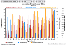
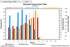
M Current meteo and climatic data for the Blüemlisalp glacier.
The meteorological/climate data from the MeteoSwiss measuring stations closest to the Blüemlisalp glacier have been available since December 2023. You can call up the daily and monthly values for temperature (incl. min/max values), precipitation and sunshine duration, a comparison with the climate standard values and exceptional weather events. Links to the nearest snow depth measuring stations on the Blüemlisalp glacier round off the offer.
The image comparisons of this page were created with the software
Before/After images.