C Location 1
Updated : 16.10.2025
Height: 2765m Viewing angle: 192° Viewing direction center of photo: E
Compare the situation from with that from (<<< select date) Period of time: 5808 days (= 15.91 years)
The
terms of use for these repeat photos can be found
here...
Direct link... C Location 2
Inserted / Updated : 31.07.2017 / 14.08.2018
Height: 2743m Viewing angle: 175° Viewing direction center of photo: NNE
Compare the situation from with that from (<<< select date) Period of time: 4684 days (= 12.83 years)
The
terms of use for these repeat photos can be found
here...
Direct link...
Auf der Aufnahme von 2018 ist etwas rechts der Bildmitte eine Person zu sehen (Grössevergleich). Auf derselben Aufnahme ist der Schnee im Vordergrund und hinten links ein Rest des schneereichen Winters 2017/18. Bis im Herbst wird dieser Schnee geschmolzen sein.
C Location 4 Inserted: 20.10.2022
Height: 2758m Viewing angle: 228° Viewing direction center of photo: SE (126°)
Image comparison period: 16.08.2016 - 11.07.2022 Period of time: 2155 days (= 5.90 years)
The
terms of use for these repeat photos can be found
here...
Direct link...
16.08.2016: The area covered by the lake was still under ice a few years before. Drainage was via an above-ground drain to the right. To be seen e.g. on the 2016 panorama photo of site 1.
11.07.2022: Due to the melting of the glacier, the surface runoff shifted further and further away from the location 4. As can be seen in the overview photo (aerial photograph) from 2018, the runoff was still above ground at that time. On 11.7.2022, the water flowed out via glacier. The level of the lake has dropped markedly. The appearance of this area has changed considerably.
Furthermore, the area on the left can be nicely seen in these repeat photos as it was lowered by the melting of the ice. I.e. what looked like a scree slope was a part of the Chaltwater Glacier covered with debris.
C Location 5 Inserted: 10.06.2018
Height: 2828m Viewing angle: 145° Viewing direction center of photo: SSE (162°)
Image comparison period: 17.08.2014 - 16.08.2016 Period of time: 730 days (= 2.00 years)
The
terms of use for these repeat photos can be found
here...
Direct link...
O Overview Chaltwasser Glacier Photo from 3.8.2018
Horizontal distance point 1 -> point 5: approx. 420m
P Interactive panoramic photos of the Chaltwasser glacierAfter clicking on a preview photo, the panorama photo is displayed in a new window.
03.08.2018
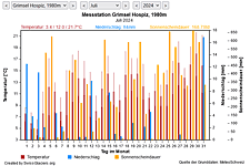
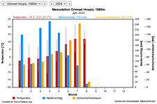
M Current meteo and climatic data for the Chaltwasser glacier.
The meteorological/climate data from the MeteoSwiss measuring stations closest to the Chaltwasser glacier have been available since December 2023. You can call up the daily and monthly values for temperature (incl. min/max values), precipitation and sunshine duration, a comparison with the climate standard values and exceptional weather events. Links to the nearest snow depth measuring stations on the Chaltwasser glacier round off the offer.
The image comparisons of this page were created with the software
Before/After images.