C Location 1
Updated : 06.12.2021
Height: 2730m Viewing angle: 90° Viewing direction center of photo: NW
Compare the situation from with that from (<<< select date) Period of time: 4763 days (= 13.05 years)
The
terms of use for these repeat photos can be found
here...
Direct link...
This comparison shows the area of the glacier tongue. The glacier shrinkage (length and mass) of the last 10 years is clearly visible. In the background you can see the tongue of the Hohlaub Glacier.
C Location 2
Updated : 17.11.2018
Height: 2870m Viewing angle: 200° Viewing direction center of photo: NW
Compare the situation from with that from (<<< select date) Period of time: 3648 days (= 9.99 years)
The
terms of use for these repeat photos can be found
here...
Direct link...
This comparison shows the Allalin Glacier from the glacier tongue up to an altitude of about 3500m. The progressive melting of the glacier can be seen particularly well on the rocky island in the drop line of the Allalinhorn summit. This island has become much bigger in the last 10 years. The same can be observed in the area of the glacier tongue.
O Overview Allalin glacier Photo from 29.7.2018
Horizontal distance point 1 -> point 2: approx. 340m
P Interactive panoramic photos of the Allalin glacierAfter clicking on a preview photo, the panorama photo is displayed in a new window.
29.07.2018
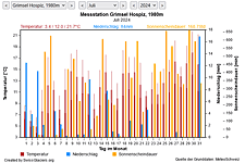
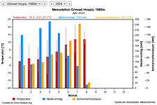
M Current meteo and climatic data for the Allalin glacier.
The meteorological/climate data from the MeteoSwiss measuring stations closest to the Allalin glacier have been available since December 2023. You can call up the daily and monthly values for temperature (incl. min/max values), precipitation and sunshine duration, a comparison with the climate standard values and exceptional weather events. Links to the nearest snow depth measuring stations on the Allalin glacier round off the offer.
The image comparisons of this page were created with the software
Before/After images.