Display photos:
Before/after comparison photo of Hobärg glacier (Valais alps)
Height: ca. 2810 - 4540m
Location: Randa, Mattertal, Valais, Switzerland
Show glacier on:
Swiss map...
The Hobärggletscher (formerly Hohbergletscher) is located on the east
side of the Mischabel massif. It extends from the 4546m high Dom (=
highest peak lying entirely in Switzerland) to a height of 2800m above
sea level. It is surrounded by the 4000m high Dirruhorn (4035m, formerly
Dürrenhorn), Hobärghorn (4218m, formerly Hohberghorn), Stecknadelhorn
(4240m), Nadelhorn (4327m), Lenzspitze (4293m) and Dom (4546m).
On
the normal route to Dom, one enters the Hobärggletscher after crossing
the Festjoch (3722m). The route then leads to the summit over the
Hobärggletscher.
C Location 1 Inserted: 29.10.2020
Height: 2226m Viewing direction center of photo: NE (57°)
Image comparison period: 20.07.2015 - 22.07.2019 Period of time: 1463 days (= 4.01 years)
The
terms of use for these repeat photos can be found
here...
Direct link...
The horizontal distance from the location to the glacier tongue is about 7.5km.
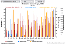
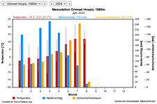
M Current meteo and climatic data for the Hobärg glacier.
The meteorological/climate data from the MeteoSwiss measuring stations closest to the Hobärg glacier have been available since December 2023. You can call up the daily and monthly values for temperature (incl. min/max values), precipitation and sunshine duration, a comparison with the climate standard values and exceptional weather events. Links to the nearest snow depth measuring stations on the Hobärg glacier round off the offer.
Show from Hobärg glacier:Photos
The image comparisons of this page were created with the software
Before/After images.
|<<>>|Overview C M I