C Location 1
Updated : 19.02.2022
Height: 2350m Viewing angle: 195° Viewing direction center of photo: Süden
Compare the situation from with that from (<<< select date) Period of time: 4070 days (= 11.15 years)
The
terms of use for these repeat photos can be found
here...
Direct link...
The panoramic photo of 2010 was taken from a point 10-15m east of the 2012 photo.
The lateral glacier gate (northern side), from which a lot of water flowed out in 2012, has melted away to 100%. The dried up brook bed can be seen on the photographs from 2014 onwards in the foreground. A lot of water now drains off via a new gate, which is located in the ice covered with a lot of debris on the northern slope at the foot of the Löffelhorn. The new glacier gate can be seen well on the photos from 2014 onwards.
C Location 4
Inserted / Updated : 10.07.2017 / 29.11.2025
Height: 2370m Viewing angle: 196° Viewing direction center of photo: S (173°)
Compare the situation from with that from (<<< select date) Period of time: 3987 days (= 10.92 years)
The
terms of use for these repeat photos can be found
here...
Direct link...
18.07.2025: The reference point was moved a few metres to the west. This point should be easier to find than the previous position.
This site, which was still covered by the ice until the end of 2012 / beginning of 2013, is located opposite location 3 (on top of the glacier cut / hill approx., in the middle of the picture).
A person can be seen on the right edge of the 2017 image.
The curvature of the various panoramic photos differs, which leads to the poor accuracy of fit.
C Location 3
Inserted / Updated : 25.07.2016 / 09.12.2019
Height: 2377m Viewing angle: 140° Viewing direction center of photo: SW
Compare the situation from with that from (<<< select date) Period of time: 2554 days (= 7.00 years)
The
terms of use for these repeat photos can be found
here...
Direct link...
In 2012, part of the glacier water flowed through a lateral glacier gate. Two years later, the glacier gate was no longer there.
C Location 7
Inserted / Updated : 21.08.2017 / 14.01.2025
Height: 2374m Viewing angle: 255° Viewing direction center of photo: SSW
This photo location was still covered by ice in 2015. The panoramic photos of this before/after comparison show exemplarily how the terrain can change after the ice has melted.
Compare the situation from with that from (<<< select date) Period of time: 2947 days (= 8.07 years)
The
terms of use for these repeat photos can be found
here...
Direct link...
11.07.2016: The boulder from which the panoramic photo was taken was 100% surrounded by ice on 11.7.2016.
C Location 4a
Inserted: 07.02.2022
Height: 2370m Viewing angle: 81° Viewing direction center of photo: WNW (ca. 295°)
These repeat photos show the changes to a portion of the northern lateral moraine, including the landslide/debris flow mentioned in the before/after photo comparison of
location 7 (photo taken 2.7.2018).
Compare the situation from with that from (<<< select date) Period of time: 1414 days (= 3.87 years)
The
terms of use for these repeat photos can be found
here...
Direct link...
18.08.2014: The Oberrar glacier (Oberrargletscher) reaches laterally almost to the foot of the northern lateral moraine.
02.07.2018: Since the photo taken on 4.7.2017, a landslide / debris flow has detached from the northern moraine.
A little to the right of the center of the photo, the outcrop can be seen above.
On the left, the debris cone of the landslide / debris flow can be seen, which just reached the glacier.
On the photo taken on 4.7.2017, a person can be seen as a size comparison.
C Location 14
Inserted / Updated : 27.01.2022 / 05.03.2025
Height: 2375m Viewing angle: 206° Viewing direction center of photo: SSE (160°)
Compare the situation from with that from (<<< select date) Period of time: 2226 days (= 6.10 years)
The
terms of use for these repeat photos can be found
here...
Direct link...
02.07.2018: On the left of the photo a person is shown as a size comparison. The person is standing on the cone of the debris flow, which detached from the northern lateral moraine in spring 2018.
In early July 2018, there was still a relatively large amount of snow on the visible area of Oberaar glaciers (Oberaargletscher).
C Location 5
Inserted / Updated : 22.11.2022 / 04.07.2025
Height: 2346m Viewing angle: 195° Viewing direction center of photo: SSE (162°)
Compare the situation from with that from (<<< select date) Period of time: 3640 days (= 9.97 years)
The
terms of use for these repeat photos can be found
here...
Direct link... C Location 8
Inserted / Updated : 07.09.2017 / 07.05.2025
Height: 2339m Viewing angle: 210° Viewing direction center of photo: S (177°)
Compare the situation from with that from (<<< select date) Period of time: 2947 days (= 8.07 years)
The
terms of use for these repeat photos can be found
here...
Direct link...
In summer/autumn 2015, part of the glacier collapsed in the area of the glacier tongue. This comparison shows how quickly the main outflow of the Oberaar glacier was uncovered by the melting ice and how quickly the uncovered area increased.
C Location 15
Inserted / Updated : 17.11.2022 / 05.05.2024
Height: 2317m Viewing angle: 203° Viewing direction center of photo: S (174°)
Compare the situation from with that from (<<< select date) Period of time: 1841 days (= 5.04 years)
The
terms of use for these repeat photos can be found
here...
Direct link...
02.07.2018: On the right edge of the picture, a person is standing in front of the glacier.
C Location 16
Inserted / Updated : 30.04.2021 / 13.11.2022
Height: 2320m
Compare the situation from with that from (<<< select date) Period of time: 1461 days (= 4.00 years)
The
terms of use for these repeat photos can be found
here...
Direct link...
02.07.2022: The photo was taken during one of the hot spells of the summer of 2022. To the right of the rock in the foreground, wet, washed-up sand can be seen. This means that water from the glacial stream flowed into the hollow the day before. In the afternoon of the day the photo was taken, the glacial stream had a lot of water and the hollow was probably flooded again.
These repeat photos show the evolution of the glacier gate as of 2018.
Height: 2325m Viewing angle: 180° Viewing direction center of photo: WSW
Image comparison period: 28.06.2010 - 16.07.2012 Period of time: 749 days (= 2.05 years)
The
terms of use for these repeat photos can be found
here...
Direct link...
Both panorama photos were not taken exactly from the same point (newer photo = 5-10m east).
C Location 12
Inserted / Updated : 29.04.2018 / 24.09.2020
Height: 2764m Viewing angle: 11° Viewing direction center of photo: WSW (255°)
Compare the situation from with that from (<<< select date) Period of time: 5442 days (= 14.91 years)
The
terms of use for these repeat photos can be found
here...
Direct link...
Horizontal distance photo location - glacier tongue 2005: approx. 6.5km.
Despite the large distance and the frontal view, the changes are clearly visible.
O Overview Oberaar gletscher Photo from 24.7.2018
Horizontal distance point 1 -> point 7: approx. 315m
Locations 2 and 12 are not shown in the overview photo.
P Interactive panoramic photos of the Oberaar glacierAfter clicking on a preview photo, the panorama photo is displayed in a new window.
18.07.2025
17.07.2023
13.07.2020
14.07.2019
24.07.2018
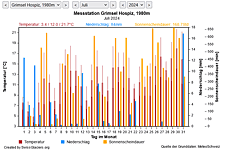
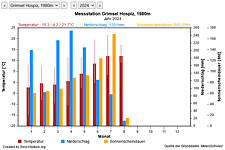
M Current meteo and climatic data for the Oberaar glacier.
The meteorological/climate data from the MeteoSwiss measuring stations closest to the Oberaar glacier have been available since December 2023. You can call up the daily and monthly values for temperature (incl. min/max values), precipitation and sunshine duration, a comparison with the climate standard values and exceptional weather events. Links to the nearest snow depth measuring stations on the Oberaar glacier round off the offer.