C Location 1
Inserted / Updated : 10.09.2020 / 17.11.2025
Height: 2750m Viewing direction center of photo: WSW
These repeat photos show the Wildhorn and its glaciers from ENE (59°). Distance: 35km.
Left of the summit: Glacier de Téné (Glacier du Wildhorn).
Right of the summit: Tungel glacier.
Compare the situation from with that from (<<< select date) Period of time: 5118 days (= 14.02 years)
The
terms of use for these repeat photos can be found
here...
Direct link...
03.09.2011: This photo was taken on a day with relatively poor visibility. Although the haze could be greatly reduced with image processing, the image quality unfortunately suffered as a result.
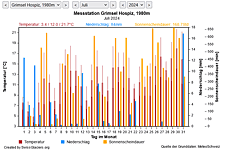
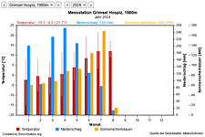
M Current meteo and climatic data for the Glacier de Téné.
The meteorological/climate data from the MeteoSwiss measuring stations closest to the Glacier de Téné have been available since December 2023. You can call up the daily and monthly values for temperature (incl. min/max values), precipitation and sunshine duration, a comparison with the climate standard values and exceptional weather events. Links to the nearest snow depth measuring stations on the Glacier de Téné round off the offer.
The image comparisons of this page were created with the software
Before/After images.