Display photos:
Before/after comparison photo of Eiger glacier (Bernese Alps)
Height: ca. 2450 - 3550m
Location: Grindelwald, Bernese Oberland, Switzerland
Show glacier on:
Swiss map...
GLAMOS...
The Eiger Glacier flows from the foot of the south flank of the Eiger (3967m) south past the Chlyne Eiger (3466m) towards the west down to an altitude of about 2450m (2020). While the lower part of the Eiger glacier can be seen very well from the Jungfrau Railways station of the same name, the upper part is hidden by the Chly Eiger. The Eiger Glacier is an optically important part of the unique triumvirate of Eiger, Mönch and Jungfrau. The Eiger Glacier has practically no alpine significance.
C Location 1
Inserted / Updated : 03.09.2020 / 29.11.2023
Height: 2750m Viewing direction center of photo: ENE (72°)
Compare the situation from with that from (<<< select date) Period of time: 2943 days (= 8.06 years)
The
terms of use for these repeat photos can be found
here...
Direct link...
The repeat photos show the Eiger glacier from a distance of 19km. Location: Summit of the Bundstock, 2755m ü.M.
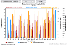
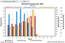
M Current meteo and climatic data for the Eiger glacier.
The meteorological/climate data from the MeteoSwiss measuring stations closest to the Eiger glacier have been available since December 2023. You can call up the daily and monthly values for temperature (incl. min/max values), precipitation and sunshine duration, a comparison with the climate standard values and exceptional weather events. Links to the nearest snow depth measuring stations on the Eiger glacier round off the offer.
The image comparisons of this page were created with the software
Before/After images.
|<<>>|Overview C M I