C Full glacier
Updated : 11.03.2025
Height: 2750m Viewing angle: 22° Viewing direction center of photo: SSW
Compare the situation from with that from (<<< select date) Period of time: 6998 days (= 19.17 years)
The
terms of use for these repeat photos can be found
here...
Direct link...
On the right you can see the "Spitze Stei". In the middle of March 2019, an estimated 15 million cubic metres of rock moved downhill at a rate of 4 mm per day. The photo taken on 19.10.2018 shows that the Doldenhorn north face is rarely illuminated by the sun so late in the year.
Distance from photo location to glacier tongue: approx. 4.5km.
C Bergschrund
Inserted / Updated : 10.09.2023 / 06.12.2025
Height: 2730m Viewing direction center of photo: SSW (195°)
Below the saddle between Doldenhorn (3628m, top left) and Kleindoldenhorn (3474m, top right), an exceptionally large bergschrund opened in summer 2022.
Compare the situation from with that from (<<< select date) Period of time: 1467 days (= 4.02 years)
The
terms of use for these repeat photos can be found
here...
Direct link...
Summit on the right: Kleindoldenhorn (3474m). Height of the knee in the glacier: ca. 3180m (measured at mean elevation of the knee on map.admin.ch).
Possible cause: As a result of the persistently high temperatures in summer 2022, meltwater reduced the adhesion of the ice to the downslope bedrock slabs. As a result, the entire mass of ice slowly slid down.
Height: 2570m Viewing angle: 9° Viewing direction center of photo: SSW
Image comparison period: 26.06.2005 - 03.09.2011 Period of time: 2260 days (= 6.19 years)
The
terms of use for these repeat photos can be found
here...
Direct link... C Glacier tongue
Inserted / Updated : 16.06.2016 / 27.05.2025
Height: 2570m Viewing angle: 11° Viewing direction center of photo: SSW
Compare the situation from with that from (<<< select date) Period of time: 6998 days (= 19.17 years)
The
terms of use for these repeat photos can be found
here...
Direct link... C Spitze Stei
Inserted / Updated : 15.01.2020 / 14.09.2023
Height: 2750m Viewing direction center of photo: SSW (210°)
This photo comparison shows the Spitze Stei and the slope below the Spitze Stei. This flank has been moving downhill since summer 2018. The volume of the rock masses in movement is several million cubic meters. One of the causes of these movements is melting permafrost.
Compare the situation from with that from (<<< select date) Period of time: 4362 days (= 11.95 years)
The
terms of use for these repeat photos can be found
here...
Direct link...
The horizontal distance from the place of recording to the Spize Stei (top left of the picture) is 4.6 km.
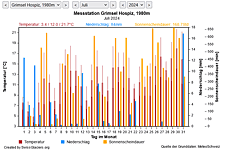
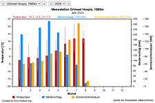
M Current meteo and climatic data for the Doldenhorn glacier.
The meteorological/climate data from the MeteoSwiss measuring stations closest to the Doldenhorn glacier have been available since December 2023. You can call up the daily and monthly values for temperature (incl. min/max values), precipitation and sunshine duration, a comparison with the climate standard values and exceptional weather events. Links to the nearest snow depth measuring stations on the Doldenhorn glacier round off the offer.
The image comparisons of this page were created with the software
Before/After images.