Display photos:
Before/after comparison of Kin glacier (Valais alps, Switzerland)
Height: ca. 3080 - 4400m.ü.M
Location: Randa, Mattertal, Valais, Switzerland
Show glacier on:
Swiss map...
The Kin glacier (Kingletscher) is located on the west side of the Mischabel massif, which is over 4500m high (highest peak: Dom, 4545m). One of the routes leads over the Kingletscher to the 4494m high Täschhorn.
Height: 2226m Viewing angle: 16° Viewing direction center of photo: ENE (81°)
Image comparison period: 20.07.2015 - 22.07.2019 Period of time: 1463 days (= 4.01 years)
The
terms of use for these repeat photos can be found
here...
Direct link...
The horizontal distance from the place of recording to the left glacier tongue is 6.7km.
Summits: Dom, 4545m (left) and Täschhorn (4491m). In between the Domjoch, 4278m.
It is clearly visible how the ice in the steep summit area has flowed downhill in recent years and gained mass. If the mass exceeds a certain size, a part of this area will break off.
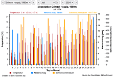
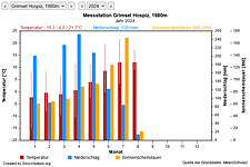
M Current meteo and climatic data for the Kin glacier.
The meteorological/climate data from the MeteoSwiss measuring stations closest to the Kin glacier have been available since December 2023. You can call up the daily and monthly values for temperature (incl. min/max values), precipitation and sunshine duration, a comparison with the climate standard values and exceptional weather events. Links to the nearest snow depth measuring stations on the Kin glacier round off the offer.
The image comparisons of this page were created with the software
Before/After images.
|<<>>|Overview C M I